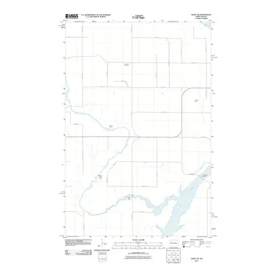
2011 Map of Dazey NE
USGS Topo · Published 2011About this map
Lake Ashtabula dominates the southeastern quadrant of this Barnes County landscape, where the waters are contained by a series of regional water management features. The meandering path of Baldhill Creek defines the local topography, punctuated by smaller impoundments such as Baldhill Creek Dam, Berger Dam, and Heinze Dam. These structures reflect the 20th-century history of water control and land use in the Red River Valley region. Cultural landmarks are sparse but significant for local history, including Sunnyside Cemetery situated along the section lines and Wesley Acres Camp positioned near the lake's western shore. The map illustrates a classic North Dakota section-line road grid, with routes like 115th Ave SE and 14th St SE providing access to the expansive agricultural tracts that surround the creek valley.
Find a feature on this map
25 named features on this map. Tap any name to fly to it.
Don’t see what you’re looking for? This feature index may not catch every label — zoom into the map to look around manually.
Map Details
Editions of this 2011 Dazey NE Map
This is the sole edition of this map. No revisions or reprints were ever made.
Other maps of this area

1952 · Grand Forks
USGS Topo · 1:250,000

1952 · New Rockford
USGS Topo · 1:250,000

1956 · New Rockford
USGS Topo · 1:250,000

1956 · Grand Forks
USGS Topo · 1:250,000

1961 · Baldhill Dam
USGS Topo · 1:24,000

1961 · Hannaford
USGS Topo · 1:24,000

1961 · Rogers
USGS Topo · 1:24,000

1961 · Dazey NE
USGS Topo · 1:24,000

1961 · Dazey
USGS Topo · 1:24,000

1961 · Karnak
USGS Topo · 1:24,000
Featured Places
- Ashtabula Township, ND
- Rogers Township, ND
- Sibley Trail Township, ND
- Dazey Township, ND
- Barnes County, ND