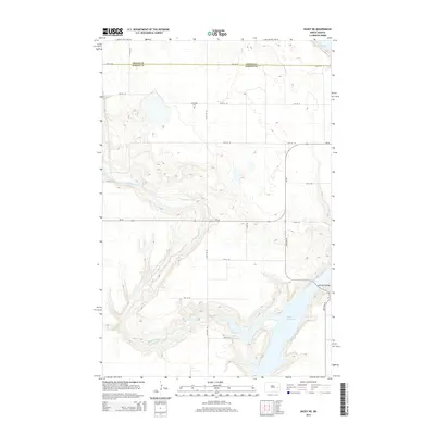
2014 Map of Dazey NE
USGS Topo · Published 2014About this map
Lake Ashtabula dominates the southeastern portion of this landscape, its waters framed by steep, complex contouring that marks the edge of the glacial valley. The map documents the northern reaches of the reservoir where it meets Baldhill Creek, a waterway that carves a deep, winding path through the prairie before joining the lake. This 2014 survey records a largely rural agricultural area spanning the border of Griggs Co Barnes Co, characterized by a strictly organized section-line road grid that defines the upland terrain. Notable landmarks for local history include the Sunnyside Cem, situated in the northern section of the quadrangle, and the Ashtabula Bridge which crosses the reservoir's narrower northern neck. The landscape is defined by the contrast between the flat, productive tablelands above and the sharp elevation drops leading toward the river valley bottomlands.
Find a feature on this map
14 named features on this map. Tap any name to fly to it.
Don’t see what you’re looking for? This feature index may not catch every label — zoom into the map to look around manually.
Map Details
Editions of this 2014 Dazey NE Map
This is the sole edition of this map. No revisions or reprints were ever made.
Other maps of this area

1952 · Grand Forks
USGS Topo · 1:250,000

1952 · New Rockford
USGS Topo · 1:250,000

1956 · New Rockford
USGS Topo · 1:250,000

1956 · Grand Forks
USGS Topo · 1:250,000

1961 · Baldhill Dam
USGS Topo · 1:24,000

1961 · Hannaford
USGS Topo · 1:24,000

1961 · Rogers
USGS Topo · 1:24,000

1961 · Dazey NE
USGS Topo · 1:24,000

1961 · Dazey
USGS Topo · 1:24,000

1961 · Karnak
USGS Topo · 1:24,000
Featured Places
- Ashtabula Township, ND
- Rogers Township, ND
- Sibley Trail Township, ND
- Dazey Township, ND
- Barnes County, ND