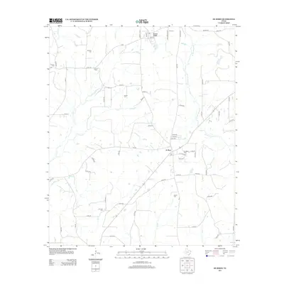
2013 Map of De Berry
USGS Topo · Published 2013About this map
Elysian Fields and De Berry anchor this rural East Texas landscape, where the terrain is defined by a dense network of creek drainages including W Fork Socagee Cr, Jackson Cr, and Tuttle Cr. The survey reveals a high concentration of small, family-named burial grounds that speak to the area's deep genealogical roots, from the Woodley Cem in the northwest to the Fourmile Cem in the south. This distribution of sites like Markrider Cem and Bracken Cem suggests a long-standing pattern of dispersed family homesteads rather than centralized urban growth. Near the settlement of De Berry, a cluster of sites including Evergreen Cem and Ruck Cem marks the local community's center, while Furrh Lake stands out as a primary water feature in the northeast corner.
Find a feature on this map
69 named features on this map. Tap any name to fly to it.
Don’t see what you’re looking for? This feature index may not catch every label — zoom into the map to look around manually.
Map Details
Editions of this 2013 De Berry Map
This is the sole edition of this map. No revisions or reprints were ever made.
Other maps of this area

1943 · Waskom
USGS Topo · 1:62,500

1945 · Waskom
USGS Topo · 1:62,500

1945 · Socagee Bayou
USGS Topo · 1:62,500

1956 · Tyler
USGS Topo · 1:250,000

1956 · Deadwood
USGS Topo · 1:62,500

1958 · Darco
USGS Topo · 1:62,500

1958 · Carthage
USGS Topo · 1:62,500

1962 · Stricklin Springs
USGS Topo · 1:24,000

1962 · De Berry
USGS Topo · 1:24,000
1962 · Panola
USGS Topo · 1:24,000