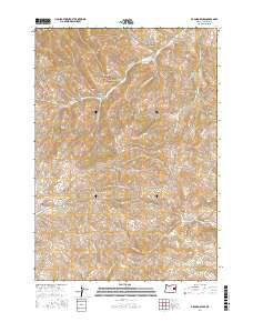
2017 Map of De Bord Peaks
USGS Topo · Published 2017About this map
De Bord Peaks and Taxspa Butte anchor this high-elevation terrain in eastern Oregon, where a complex network of seasonal drainages carves through the landscape. The geography is defined by narrow canyons and gulches, including Sheep Dip Canyon, Black Stump Canyon, and Rail Canyon. These landforms suggest a history of seasonal grazing and water management, particularly evident in the naming of Sheep Dip Canyon.
Find a feature on this map
23 named features on this map. Tap any name to fly to it.
Don’t see what you’re looking for? This feature index may not catch every label — zoom into the map to look around manually.
Map Details
Editions of this 2017 De Bord Peaks Map
This is the sole edition of this map. No revisions or reprints were ever made.
Other maps of this area

1908 · Ironside Mountain
USGS Topo · 1:125,000

1955 · Baker
USGS Topo · 1:250,000

1955 · Canyon City
USGS Topo · 1:250,000

1959 · Baker
USGS Topo · 1:250,000

1959 · Canyon City
USGS Topo · 1:250,000

1964 · Ironside
USGS Topo · 1:62,500

1966 · Clover Creek Ranch
USGS Topo · 1:62,500

1970 · Castle Rock
USGS Topo · 1:62,500
1972 · Rastus Mtn
USGS Topo · 1:24,000
1972 · Eldorado Pass
USGS Topo · 1:24,000