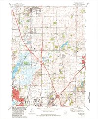
1983 Map of De Forest
USGS Topo · Published 1984About this map
The Yahara River and its intricate wetlands define the landscape north of Madison in this early 1980s topographic study. The transition from rural agriculture to suburban expansion is visible in the corridor between De Forest and the northern edge of the state capital. Vital community hubs like the Norway Grove Ch and the Pumpkin Hollow Sch are preserved here, alongside significant military and conservation footprints including Truax Field and the Cherokee Marsh State Fishery Area. To the east, the village of Sun Prairie marks the map's border, while the winding course of Token Creek feeds into the Token Creek Pond. This map captures a specific moment when the regional economy, anchored by the Chicago Milwaukee St Paul and Pacific railroad, balanced its industrial needs with local landmarks like the Drive-in Theater and numerous gravel pits and quarries.
Find a feature on this map
63 named features on this map. Tap any name to fly to it.
Don’t see what you’re looking for? This feature index may not catch every label — zoom into the map to look around manually.
Map Details
Editions of this 1983 De Forest Map
This is the sole edition of this map. No revisions or reprints were ever made.
Other maps of this area

1890 · Madison
USGS Topo · 1:62,500

1890 · Sun Prairie
USGS Topo · 1:62,500

1892 · Madison
USGS Topo · 1:62,500

1896 · Sun Prairie
USGS Topo · 1:62,500

1901 · Poynette
USGS Topo · 1:62,500

1904 · Madison
USGS Topo · 1:62,500

1905 · Sun Prairie
USGS Topo · 1:62,500

1906 · Madison
USGS Topo · 1:62,500

1907 · Sun Prairie
USGS Topo · 1:62,500

1955 · Columbus
USGS Topo · 1:62,500