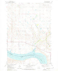
1973 Map of De Grey
USGS Topo · Published 1976About this map
Lake Sharpe dominates the southern portion of this landscape, its waters covering the historic channel of the Missouri River along the boundary between Hughes and Stanley counties. The small community of De Grey sits north of the reservoir, anchored by the De Grey Sch and a local Cem, reflecting the rural social structure of central South Dakota in the 1970s. Further south, across the water, the Lower Brule Indian Res Bdy marks the northern extent of tribal lands. To the north, the terrain transitions into the broad depressions of Pleasant Valley and the high ground of the De Grey plateau. Local infrastructure is sparse, characterized by a Gravel Pit near the river bluffs and a Flowing Well to the west. The De Grey Recreation Area and its Boat Ramp indicate the river's shift from a commercial artery to a site of modern recreational use.
Find a feature on this map
19 named features on this map. Tap any name to fly to it.
Don’t see what you’re looking for? This feature index may not catch every label — zoom into the map to look around manually.
Map Details
Editions of this 1973 De Grey Map
This is the sole edition of this map. No revisions or reprints were ever made.
Other maps of this area

1934 · Canning
USGS Topo · 1:48,000

1937 · Canning
USGS Topo · 1:62,500

1953 · Huron
USGS Topo · 1:250,000

1954 · Pierre
USGS Topo · 1:250,000

1954 · Huron
USGS Topo · 1:250,000

1958 · Pierre
USGS Topo · 1:250,000

1966 · Joe Creek
USGS Topo · 1:24,000

1966 · Joe Creek NW
USGS Topo · 1:24,000

1967 · Canning
USGS Topo · 1:24,000

1967 · De Grey NE
USGS Topo · 1:24,000