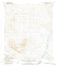
1955 Map of De Long Mountains D-1
USGS Topo · Published 1967About this map
Poko Mountain dominates the central landscape of this mid-century survey, rising above a network of northern waterways and unmarked land lines. The Kokolik River winds through the eastern portion of the sheet, joined by the Tingmerkpuk River and various unnamed tributaries that drain the surrounding high ground. Topography was established by photogrammetric methods from 1955 aerial photography, reflecting the wilderness state of the region during the post-war era of Arctic mapping. Scattered landmark points like Ginn and Poko provide specific surveying references across the terrain. Notable for its lack of roads or established settlements, the map illustrates the remote drainage patterns of Tupikchak Creek and Surprise Creek as they existed before modern development or resource extraction altered the North Slope's natural drainage basins.
Find a feature on this map
7 named features on this map. Tap any name to fly to it.
Don’t see what you’re looking for? This feature index may not catch every label — zoom into the map to look around manually.
Map Details
Editions of this 1955 De Long Mountains D-1 Map
This is the sole edition of this map. No revisions or reprints were ever made.
Other maps of this area

1951 · De Long Mountains
USGS Topo · 1:250,000

1951 · Utukok River
USGS Topo · 1:250,000

1951 · Point Lay
USGS Topo · 1:250,000

1951 · Misheguk Mountain
USGS Topo · 1:250,000

1955 · De Long Mountains
USGS Topo · 1:250,000

1955 · Point Lay
USGS Topo · 1:250,000
1955 · Utukok River A-5
USGS Topo · 1:63,360

1955 · Point Lay A-1
USGS Topo · 1:63,360

1955 · De Long Mountains D-2
USGS Topo · 1:63,360
1955 · De Long Mountains C-2
USGS Topo · 1:63,360