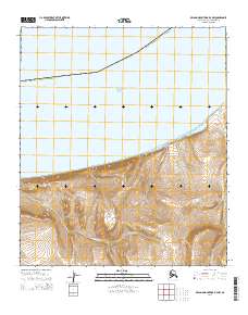
2014 Map of De Long Mountains D-4 NW
USGS Topo · Published 2014About this map
The Chukchi Sea coastline defines this portion of the Alaska North Slope Borough, where the land meets the Arctic waters along a relatively straight, low-lying shore. The coastal geography is marked by the Punuk Lagoon and the drainage systems of several small waterways, including Ikikileruk Cr and Punuk Cr. Moving inland, the terrain rises slightly into the Punuk Hills, a localized elevation that contrasts with the surrounding tundra and stream valleys like Mutaktuk Cr. This 2014 survey records a landscape devoid of permanent settlements or infrastructure, emphasizing the remote environmental character of the De Long Mountains foothills. The map provides a clear record of the intersection between glacial-fed hydrology and the high-latitude coastline.
Find a feature on this map
7 named features on this map. Tap any name to fly to it.
Don’t see what you’re looking for? This feature index may not catch every label — zoom into the map to look around manually.
Map Details
Editions of this 2014 De Long Mountains D-4 NW Map
This is the sole edition of this map. No revisions or reprints were ever made.
Other maps of this area

1951 · De Long Mountains
USGS Topo · 1:250,000

1951 · Point Lay
USGS Topo · 1:250,000

1955 · De Long Mountains
USGS Topo · 1:250,000

1955 · Point Lay
USGS Topo · 1:250,000

1955 · De Long Mountains D-4
USGS Topo · 1:63,360
1955 · De Long Mountains D-5
USGS Topo · 1:63,360

1965 · Point Lay
USGS Topo · 1:250,000

1965 · De Long Mountains
USGS Topo · 1:250,000
2014 · Point Lay A-4 SE
USGS Topo · 1:25,000
2014 · De Long Mountains D-4 SW
USGS Topo · 1:25,000