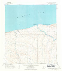
1955 Map of De Long Mountains D-5
USGS Topo · Published 1971About this map
Cape Sabine and Corwin Bluff anchor the coastline of this Arctic reach, where the Chukchi Sea meets the northern slopes of the De Long Mountains. The landscape is defined by the winding course of the Pitmegea River and its convergence with the Agiak Lagoon near the shore. Traces of human activity in this remote environment are represented by a solitary Mine near Kigiktowk Creek and the thin line of a Winter Trail that skirts the bluffs and lagoons. This mid-1950s survey captures the region just as photogrammetric methods were beginning to document the drainage patterns of Thetis Creek and the surrounding tundra elevations like Akporvik Hill in detail.
Find a feature on this map
10 named features on this map. Tap any name to fly to it.
Don’t see what you’re looking for? This feature index may not catch every label — zoom into the map to look around manually.
Map Details
Editions of this 1955 De Long Mountains D-5 Map
This is the sole edition of this map. No revisions or reprints were ever made.
Other maps of this area

1951 · De Long Mountains
USGS Topo · 1:250,000

1951 · Point Lay
USGS Topo · 1:250,000

1952 · Point Hope
USGS Topo · 1:250,000

1952 · Point Hope D-1
USGS Topo · 1:63,360

1955 · De Long Mountains
USGS Topo · 1:250,000

1955 · Point Lay
USGS Topo · 1:250,000

1955 · Point Hope
USGS Topo · 1:250,000

1955 · Point Hope C-1
USGS Topo · 1:63,360

1955 · De Long Mountains D-4
USGS Topo · 1:63,360

1955 · De Long Mountains C-4
USGS Topo · 1:63,360