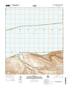
2014 Map of De Long Mountains D-5 NE
USGS Topo · Published 2014About this map
Cape Sabine defines the shoreline of this remote coastal survey, where the terrestrial landscape meets the expansive Chukchi Sea. The terrain is characterized by the winding path of the Pitmagea River and the coastal basin of Agiak Lagoon. Significant topographical landmarks include Akporvik Hill, which rises above the surrounding drainage networks. The map details a largely undeveloped portion of the North Slope Borough, focusing on the natural hydrography of the region, including smaller tributaries like Matlukak Cr. This 2014 edition provides a high-resolution look at the shifting contours of the Alaskan coastline before modern environmental changes further altered these northern habitats.
Find a feature on this map
10 named features on this map. Tap any name to fly to it.
Don’t see what you’re looking for? This feature index may not catch every label — zoom into the map to look around manually.
Map Details
Editions of this 2014 De Long Mountains D-5 NE Map
This is the sole edition of this map. No revisions or reprints were ever made.
Other maps of this area

1951 · De Long Mountains
USGS Topo · 1:250,000

1951 · Point Lay
USGS Topo · 1:250,000

1955 · De Long Mountains
USGS Topo · 1:250,000

1955 · Point Lay
USGS Topo · 1:250,000

1955 · De Long Mountains D-4
USGS Topo · 1:63,360
1955 · De Long Mountains D-5
USGS Topo · 1:63,360

1965 · Point Lay
USGS Topo · 1:250,000

1965 · De Long Mountains
USGS Topo · 1:250,000
2014 · De Long Mountains D-4 SW
USGS Topo · 1:25,000
2014 · De Long Mountains D-5 NW
USGS Topo · 1:25,000