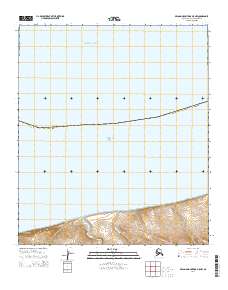
2014 Map of De Long Mountains D-5 NW
USGS Topo · Published 2014About this map
Corwin Bluff anchors the coastal topography of this Arctic landscape where the Arctic Ocean meets the Chukchi Sea. This remote segment of the Alaska North Slope Borough is defined by a sparse network of watercourses, including Thetis Cr and Kigiktowik Cr, which flow northward toward the sea. The map documents the vast, unpopulated terrain of the t6s r55w and t6s r54w townships, showing the intricate contouring of the coastal bluffs and the maritime boundary where the borough limits extend into the northern waters. This survey provides a precise modern record of shoreline and drainage patterns in a region where the landform is the primary historical indicator.
Find a feature on this map
8 named features on this map. Tap any name to fly to it.
Don’t see what you’re looking for? This feature index may not catch every label — zoom into the map to look around manually.
Map Details
Editions of this 2014 De Long Mountains D-5 NW Map
This is the sole edition of this map. No revisions or reprints were ever made.
Other maps of this area

1951 · De Long Mountains
USGS Topo · 1:250,000

1951 · Point Lay
USGS Topo · 1:250,000

1952 · Point Hope
USGS Topo · 1:250,000

1952 · Point Hope D-1
USGS Topo · 1:63,360

1955 · De Long Mountains
USGS Topo · 1:250,000

1955 · Point Lay
USGS Topo · 1:250,000

1955 · Point Hope
USGS Topo · 1:250,000
1955 · De Long Mountains D-5
USGS Topo · 1:63,360

1965 · Point Hope
USGS Topo · 1:250,000

1965 · Point Lay
USGS Topo · 1:250,000