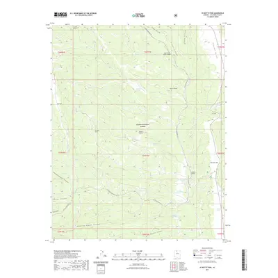
2021 Map of De Motte Park
USGS Topo · Published 2021About this map
The high Kaibab Plateau within the Kaibab National Forest defines this northern Arizona landscape, characterized by a series of high-altitude parks and canyons. Central to the area is De Motte Park, a large open meadow surrounded by dense forest, and nearby Pleasant Valley. This modern survey illustrates the distribution of essential water resources for wildlife and livestock in an otherwise arid region, including several tanks and small alpine bodies such as V T Lake, Indian Lake, and Dry Park Lakes. The map also captures the recreational footprint of the region, featuring the N Timp Snowmobile Trl as it winds across the plateau. Dramatic topographic relief is visible along V T Ridge Number Two and through deep incisions like Quaking Aspen Canyon and Franks Canyon, providing a clear record of the geological drainage patterns flowing off the plateau's heights.
Find a feature on this map
40 named features on this map. Tap any name to fly to it.
Don’t see what you’re looking for? This feature index may not catch every label — zoom into the map to look around manually.
Map Details
Editions of this 2021 De Motte Park Map
This is the sole edition of this map. No revisions or reprints were ever made.
Other maps of this area

1886 · Kaibab
USGS Topo · 1:250,000

1936 · Jacobs Lake
USGS Topo · 1:48,000

1940 · Jacob Lake
USGS Topo · 1:62,500

1953 · Jacobs Lake
USGS Topo · 1:62,500

1953 · Grand Canyon
USGS Topo · 1:250,000

1957 · Grand Canyon
USGS Topo · 1:250,000

1958 · Grand Canyon
USGS Topo · 1:250,000

1958 · Big Springs
USGS Topo · 1:62,500

1960 · Grand Canyon
USGS Topo · 1:250,000

1962 · De Motte Park
USGS Topo · 1:62,500