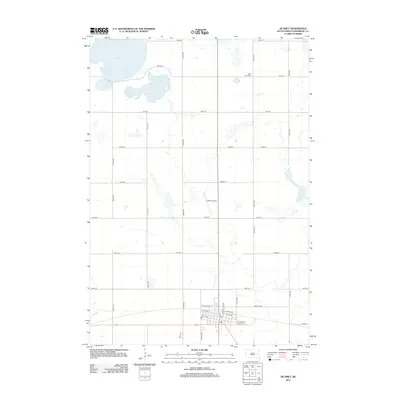
2012 Map of De Smet
USGS Topo · Published 2012About this map
De Smet serves as the focal point of this Kingsbury County landscape, where the town's grid is defined by thoroughfares such as Calumet Ave NE and Prairie Ave. The surrounding prairie is marked by a network of sectional roads and glacial water bodies, most notably Spirit Lake and the adjacent Mud Lake to the north. This mapping of the early twenty-first century captures the rural infrastructure that supports the region's agricultural character and the legacy of its famous early residents. Local history is anchored by sites like the Spirit Lake Cem and the Wilder Airport, while the central town core maintains its essential services, including the local Po. The layout of the streets, including Front St NW and Chase St NE, provides a clear view of the settlement's organized growth and its relationship to the open South Dakota plains.
Find a feature on this map
31 named features on this map. Tap any name to fly to it.
Don’t see what you’re looking for? This feature index may not catch every label — zoom into the map to look around manually.
Map Details
Editions of this 2012 De Smet Map
This is the sole edition of this map. No revisions or reprints were ever made.
Other maps of this area

1899 · De Smet
USGS Topo · 1:125,000

1953 · Watertown
USGS Topo · 1:250,000

1958 · Watertown
USGS Topo · 1:250,000

1968 · Lake Preston West
USGS Topo · 1:24,000

1968 · Erwin
USGS Topo · 1:24,000

1971 · Bancroft East
USGS Topo · 1:24,000

1971 · De Smet
USGS Topo · 1:24,000

1971 · De Smet SE
USGS Topo · 1:24,000
1971 · Manchester
USGS Topo · 1:24,000

1973 · Bryant
USGS Topo · 1:24,000