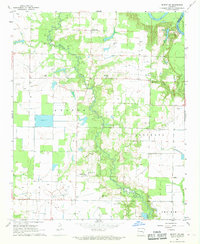
1968 Map of De Witt NE
USGS Topo · Published 1969About this map
La Grue Bayou winds through this portion of Arkansas County, defining a landscape of wetlands and timbered breaks that separate the agricultural fields of the Arkansas Grand Prairie. The small settlement of Emanuel sits at the heart of this rural area, surrounded by a network of country churches including Wofford Chapel, Shiloh Ch, and Rising Sun Ch. These landmarks, along with small burial grounds like Garrison Cem and Ferguson Cem, provide critical touchpoints for genealogists and local historians studying the mid-twentieth-century population centers of this delta region. To the north, Cooks Lake marks the edge of the White River bottomlands, while an extensive irrigation infrastructure, featuring a large Reservoir and multiple flumes, illustrates the area's intensive rice and soybean farming legacy.
Find a feature on this map
20 named features on this map. Tap any name to fly to it.
Don’t see what you’re looking for? This feature index may not catch every label — zoom into the map to look around manually.
Map Details
Editions of this 1968 De Witt NE Map
This is the sole edition of this map. No revisions or reprints were ever made.
Other maps of this area

1935 · Clarendon
USGS Topo · 1:62,500

1939 · Indian Bay
USGS Topo · 1:62,500

1940 · Holly Grove
USGS Topo · 1:62,500

1941 · De Witt
USGS Topo · 1:62,500

1941 · Clarendon
USGS Topo · 1:62,500

1948 · Helena
USGS Topo · 1:250,000

1950 · Helena
USGS Topo · 1:250,000

1954 · Indian Bay
USGS Topo · 1:62,500

1954 · De Witt
USGS Topo · 1:62,500

1955 · Helena
USGS Topo · 1:250,000