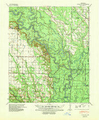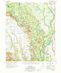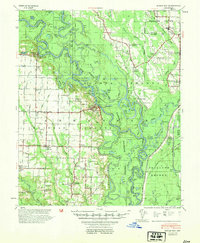
1954 Map of Indian Bay
USGS Topo · Published 1954About this map
The White River meanders through a dense network of oxbow lakes and bottomlands in this 1954 survey, defining the landscape of eastern Arkansas. This riverine environment, protected in part by the White River National Wildlife Refuge, is punctuated by dozens of named water bodies such as Lower Eagle Nest Lake, Browns Shanty Lake, and Goose Lake. The mapping reveals a distinct agricultural pattern on the higher ground surrounding the wetlands, where small communities like Indian Bay and Charles serve as local hubs.
Find a feature on this map
103 named features on this map. Tap any name to fly to it.
Don’t see what you’re looking for? This feature index may not catch every label — zoom into the map to look around manually.
Map Details
Editions of this 1954 Indian Bay Map
This is the sole edition of this map. No revisions or reprints were ever made.
Historical Maps of Saint Charles Through Time
3 maps found