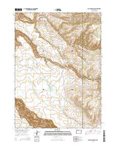
2014 Map of Deacon Crossing
USGS Topo · Published 2014About this map
Middle Fork Owyhee River carves through the high desert landscape of Malheur County, Oregon, and Owyhee County, Idaho, where water management is the primary driver of human settlement. The 2014 landscape is defined by its catchment systems, including Deacon Reservoir, Maher Reservoir, and Sharon Cr Reservoir, which sustain isolated locales such as Deacon Crossing and Deacon Field. The survey captures the intersection of the Oregon-Idaho state line with local ranching and transit features, notably the Sharon Creek Reservoir Rd. To the south, the Owyhee River flows near Owyhee Canyon, while high-altitude features like Pole Creek Basin and the Pole Creek Breaks characterize the northern sections. This cartographic study illustrates the vital role of natural springs and seasonal lakes, such as Idaho Spring and Dry Lakes, in supporting the remote high-plateau economy.
Find a feature on this map
31 named features on this map. Tap any name to fly to it.
Don’t see what you’re looking for? This feature index may not catch every label — zoom into the map to look around manually.
Map Details
Editions of this 2014 Deacon Crossing Map
This is the sole edition of this map. No revisions or reprints were ever made.
Other maps of this area

1955 · Jordan Valley
USGS Topo · 1:250,000

1957 · Jordan Valley
USGS Topo · 1:250,000

1958 · Jordan Valley
USGS Topo · 1:250,000

1973 · Bedstead Ridge
USGS Topo · 1:24,000

1973 · Fairylawn
USGS Topo · 1:24,000
1977 · Bull Basin Camp
USGS Topo · 1:24,000

1980 · Brewster Reservoir
USGS Topo · 1:24,000

1980 · Three Forks
USGS Topo · 1:24,000
1982 · Deacon Crossing
USGS Topo · 1:24,000
1982 · Rawhide Pocket
USGS Topo · 1:24,000