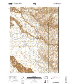
2020 Map of Deacon Crossing
USGS Topo · Published 2020About this map
Deacon Crossing sits at the heart of this high-desert landscape where Malheur County, Oregon, meets Owyhee County, Idaho. The region is defined by its sophisticated water management infrastructure, necessary for sustaining life and industry in this arid corner of the West. Significant features include State Line Reservoir, Deacon Reservoir, and Maher Reservoir, alongside natural water sources like Idaho Spring and Saddlehorse Spring. The terrain is characterized by dramatic elevation changes, from the depths of Owyhee Canyon to the rugged Pole Creek Breaks. Remote outposts such as Deacon Field and Rentile Field are connected by a network of specialized roads, including Fields Creek Reservoir Rd, which trace the contours of the Middle Fork Owyhee River and its various tributaries.
Find a feature on this map
31 named features on this map. Tap any name to fly to it.
Don’t see what you’re looking for? This feature index may not catch every label — zoom into the map to look around manually.
Map Details
Editions of this 2020 Deacon Crossing Map
This is the sole edition of this map. No revisions or reprints were ever made.
Other maps of this area

1955 · Jordan Valley
USGS Topo · 1:250,000

1957 · Jordan Valley
USGS Topo · 1:250,000

1958 · Jordan Valley
USGS Topo · 1:250,000

1973 · Bedstead Ridge
USGS Topo · 1:24,000

1973 · Fairylawn
USGS Topo · 1:24,000
1977 · Bull Basin Camp
USGS Topo · 1:24,000

1980 · Brewster Reservoir
USGS Topo · 1:24,000

1980 · Three Forks
USGS Topo · 1:24,000
1982 · Deacon Crossing
USGS Topo · 1:24,000
1982 · Rawhide Pocket
USGS Topo · 1:24,000