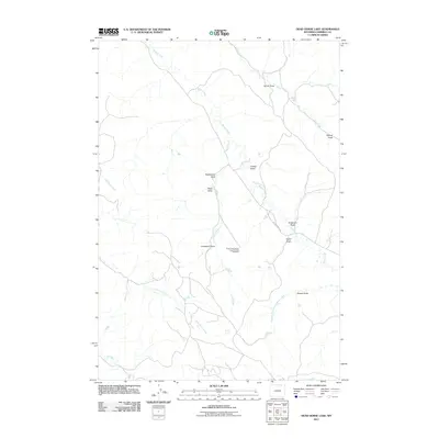
2011 Map of Dead Horse Lake
USGS Topo · Published 2011About this map
The Three Fork Canyon Area Number One Mine sits as a lonely industrial mark in this high plains landscape of Campbell County, where drainage systems define the character of the terrain. The map is dominated by the winding course of Bitter Creek and its many tributaries, including the curiously named Quarter Circle Prong Bitter Creek. These watercourses have carved numerous named draws across the land, such as Rattlesnake Draw, Rosie Draw, and Cresswell Draw, which likely served as landmarks for early ranchers and travelers. The presence of Bitter Creek Rd provides the primary arterial access through this area of the Powder River Basin. The intricate network of seasonal streams like Coal Creek and Dead Horse Creek illustrates the complex hydrology of this part of Wyoming, where water—or the memory of it—dictates the movement of people and the naming of the earth.
Find a feature on this map
19 named features on this map. Tap any name to fly to it.
Don’t see what you’re looking for? This feature index may not catch every label — zoom into the map to look around manually.
Map Details
Editions of this 2011 Dead Horse Lake Map
This is the sole edition of this map. No revisions or reprints were ever made.
Other maps of this area

1954 · Ekalaka
USGS Topo · 1:250,000

1954 · Gillette
USGS Topo · 1:250,000

1955 · Gillette
USGS Topo · 1:250,000

1956 · Ekalaka
USGS Topo · 1:250,000

1958 · Gillette
USGS Topo · 1:250,000

1958 · Ekalaka
USGS Topo · 1:250,000

1962 · Gillette
USGS Topo · 1:250,000

1965 · Ekalaka
USGS Topo · 1:250,000

1970 · Moorhead
USGS Topo · 1:24,000
1970 · Bradshaw Creek
USGS Topo · 1:24,000