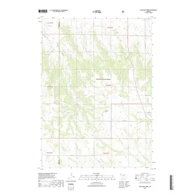
2017 Map of Dead Mans Creek
USGS Topo · Published 2017About this map
Nebraska National Forest dominates the central portion of this landscape, where the rugged drainages of the Pine Ridge region define the terrain. The map follows the boundary of Sioux Co and Dawes Co, capturing a rural area characterized by steep canyons and seasonal watercourses. The network of drainage starts with Dead Mans Cr and Cherry Cr flowing northward, while the northeast corner is marked by Dodd Reservoir. The road names reflect the local geography and historical challenges of the land, including Breakneck Rd, White River Rd, and the ominously named Starvation Gulch. This 2017 survey provides a clear look at the public land divisions and the isolated network of section roads like Diehl Rd and N Belmont Rd that serve this high-plains wilderness.
Find a feature on this map
22 named features on this map. Tap any name to fly to it.
Don’t see what you’re looking for? This feature index may not catch every label — zoom into the map to look around manually.
Map Details
Editions of this 2017 Dead Mans Creek Map
This is the sole edition of this map. No revisions or reprints were ever made.
Other maps of this area

1899 · Whistle Creek
USGS Topo · 1:125,000

1951 · Marsland
USGS Topo · 1:62,500

1955 · Alliance
USGS Topo · 1:250,000

1957 · Alliance
USGS Topo · 1:250,000

1958 · Alliance
USGS Topo · 1:250,000

1980 · Crow Butte
USGS Topo · 1:24,000

1980 · Smiley Canyon
USGS Topo · 1:24,000

1980 · Dead Mans Creek
USGS Topo · 1:24,000
1980 · Belmont
USGS Topo · 1:24,000
1980 · Crawford
USGS Topo · 1:24,000