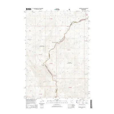
2014 Map of Deadman Lake
USGS Topo · Published 2014About this map
The Beaverhead Mountains form a high-altitude spine along the Continental Divide, where the border between Montana and Idaho follows the crest of the range. This 2014 survey documents the wilderness interface between the Beaverhead National Forest and Targhee National Forest. Historically significant as a high-mountain crossing, Bannack Pass serves as a primary transit point across the jagged ridgeline. The landscape is defined by its drainage basins, with Deadman Lake and Divide Creek Lake tucked into the high basins. Water flows through steep canyons via Deadman Cr and Nicholia Cr, while the Fritz Creek Trl provides one of the few designated routes through this high-elevation terrain. This modern survey shows how the Public Land Survey System grid interacts with the natural topography, marking boundaries like the Beaverhead Co Clark Co line.
Find a feature on this map
28 named features on this map. Tap any name to fly to it.
Don’t see what you’re looking for? This feature index may not catch every label — zoom into the map to look around manually.
Map Details
Editions of this 2014 Deadman Lake Map
This is the sole edition of this map. No revisions or reprints were ever made.
Other maps of this area

1955 · Dubois
USGS Topo · 1:250,000

1957 · Scott Peak
USGS Topo · 1:62,500

1957 · Edie Ranch
USGS Topo · 1:62,500

1958 · Dubois
USGS Topo · 1:250,000

1965 · Caboose Canyon
USGS Topo · 1:24,000

1965 · Gallagher Gulch
USGS Topo · 1:24,000

1965 · Island Butte
USGS Topo · 1:24,000

1983 · Dubois
USGS Topo · 1:100,000
1987 · Eighteenmile Peak
USGS Topo · 1:24,000
1987 · Deadman Lake
USGS Topo · 1:24,000