
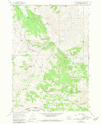
1965 Map of Gallagher Gulch
USGS Topo · Published 1968About this map
The Continental Divide defines the southwestern boundary of this high-altitude landscape, marking the border between Beaverhead County, Montana and Clark County, Idaho. This mid-1960s survey reveals a backcountry shaped by rugged drainage systems and early resource extraction. The area is dominated by the White Pine Ridge and a network of seasonal water sources including Giblo Spring, Magee Spring, and Shovel Spring.
Find a feature on this map
32 named features on this map. Tap any name to fly to it.
Don’t see what you’re looking for? This feature index may not catch every label — zoom into the map to look around manually.
Map Details
Editions of this 1965 Gallagher Gulch Map
2 editions found
Other maps of this area

1955 · Dubois
USGS Topo · 1:250,000

1957 · Scott Peak
USGS Topo · 1:62,500

1957 · Edie Ranch
USGS Topo · 1:62,500

1958 · Dubois
USGS Topo · 1:250,000

1965 · Caboose Canyon
USGS Topo · 1:24,000

1965 · Lima
USGS Topo · 1:24,000

1965 · Dixon Mountain
USGS Topo · 1:24,000

1965 · Dell
USGS Topo · 1:24,000

1965 · Lima Peaks
USGS Topo · 1:24,000

1983 · Dubois
USGS Topo · 1:100,000