
1965 Map of Lima Peaks
USGS Topo · Published 1969About this map
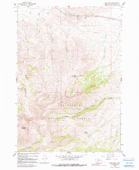
Lima Peaks and the massive profile of Garfield Mountain dominate this mid-century survey of the high-altitude terrain in Beaverhead County. The landscape is defined by the sharp transition from the northern valley floor, where the Union Pacific railroad tracks parallel Junction Creek, to the steep, densely forested slopes of the Beaverhead National Forest. This region served as active rangeland and timber country, evidenced by the presence of the Deep Creek Cow Camp and several developed water sources like Dutch Hollow Spring and Sawmill Spring. A complex network of Pack Trails and Jeep Trails provides the primary access to the remote drainages of Alder Creek and Crooked Run. The map meticulously records the numerous seasonal drainages, including Little Sheep Creek and Sawmill Creek, that carve through the peaks and feed the lower basins during the spring runoff.
Find a feature on this map
27 named features on this map. Tap any name to fly to it.
Don’t see what you’re looking for? This feature index may not catch every label — zoom into the map to look around manually.
Map Details
Editions of this 1965 Lima Peaks Map
2 editions found
Other maps of this area

1955 · Dubois
USGS Topo · 1:250,000

1957 · Paul Reservoir
USGS Topo · 1:62,500

1957 · Edie Ranch
USGS Topo · 1:62,500

1958 · Dubois
USGS Topo · 1:250,000

1965 · Gallagher Gulch
USGS Topo · 1:24,000

1965 · Lima
USGS Topo · 1:24,000

1965 · Dell
USGS Topo · 1:24,000

1968 · Snowline
USGS Topo · 1:24,000

1968 · Henry Gulch
USGS Topo · 1:24,000

1983 · Dubois
USGS Topo · 1:100,000