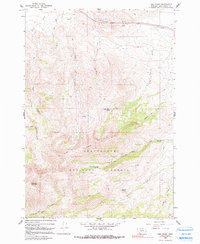
1965 Map of Lima Peaks
USGS Topo · Published 1991About this map
Beaverhead National Forest defines the southern portion of this landscape, dominated by the high elevations of Lima Peaks and the 10,961-foot summit of Garfield Mountain. The topography is characterized by a series of north-flowing drainages including Alder Creek, Truax Creek, and Willow Creek, which carve deep valleys through the mountain range.
Find a feature on this map
23 named features on this map. Tap any name to fly to it.
Don’t see what you’re looking for? This feature index may not catch every label — zoom into the map to look around manually.
Map Details
Editions of this 1965 Lima Peaks Map
2 editions found
Other maps of this area

1955 · Dubois
USGS Topo · 1:250,000

1957 · Paul Reservoir
USGS Topo · 1:62,500

1957 · Edie Ranch
USGS Topo · 1:62,500

1958 · Dubois
USGS Topo · 1:250,000

1965 · Gallagher Gulch
USGS Topo · 1:24,000

1965 · Lima
USGS Topo · 1:24,000

1965 · Dell
USGS Topo · 1:24,000

1965 · Lima Peaks
USGS Topo · 1:24,000

1968 · Snowline
USGS Topo · 1:24,000

1968 · Henry Gulch
USGS Topo · 1:24,000