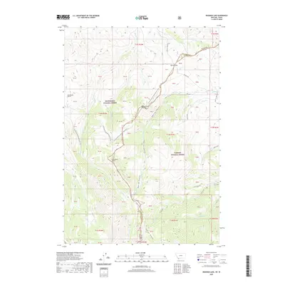
2020 Map of Deadman Lake
USGS Topo · Published 2020About this map
The Beaverhead Mountains define the high-altitude boundary between Montana and Idaho, where the Continental Divide winds through the heart of this remote wilderness. This modern survey illustrates the rugged intersection of the Beaverhead National Forest and Targhee National Forest. Human presence is marked by isolated outposts like Cow Camp and Fritz Cabin, alongside a network of high-country routes including the Continental Divide National Scenic Trail and the Webber Creek - Divide Creek Trail. The map details significant hydrologic features such as Deadman Lake and Divide Cr Lake, which feed the drainages of Deadman Cr and Fritz Creek. The topography is anchored by Bannock Pass, a key transit point through the range, and the expansive Medicine Lodge Bench to the north.
Find a feature on this map
70 named features on this map. Tap any name to fly to it.
Don’t see what you’re looking for? This feature index may not catch every label — zoom into the map to look around manually.
Map Details
Editions of this 2020 Deadman Lake Map
This is the sole edition of this map. No revisions or reprints were ever made.
Other maps of this area

1955 · Dubois
USGS Topo · 1:250,000

1957 · Scott Peak
USGS Topo · 1:62,500

1957 · Edie Ranch
USGS Topo · 1:62,500

1958 · Dubois
USGS Topo · 1:250,000

1965 · Caboose Canyon
USGS Topo · 1:24,000

1965 · Gallagher Gulch
USGS Topo · 1:24,000

1965 · Island Butte
USGS Topo · 1:24,000

1983 · Dubois
USGS Topo · 1:100,000
1987 · Eighteenmile Peak
USGS Topo · 1:24,000
1987 · Deadman Lake
USGS Topo · 1:24,000