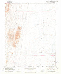
1970 Map of Deadman Spring NE
USGS Topo · Published 1973About this map
Ely Springs sits at the southern edge of a broad desert landscape where the high basin floor meets a prominent Dry Lake (Depression). Surveyed in 1969, the map reveals a remote Nevada terrain structured by the Base Line and intersected by a lonely Jeep Trail that skirts the base of the western hills. The geographic focus is on the vast Valley floor and distinctive geological markings like The Crack in the southeast. This document captures the region before extensive modern development, showing a landscape defined by its hydrography and basic surveying markers rather than dense settlement, making it a clear record of the high desert's natural state in the late twentieth century.
Find a feature on this map
10 named features on this map. Tap any name to fly to it.
Don’t see what you’re looking for? This feature index may not catch every label — zoom into the map to look around manually.
Map Details
Editions of this 1970 Deadman Spring NE Map
This is the sole edition of this map. No revisions or reprints were ever made.
Other maps of this area

1885 · Pioche
USGS Topo · 1:250,000

1886 · Pioche
USGS Topo · 1:250,000

1915 · Bristol Range
USGS Topo · 1:62,500

1916 · Highland
USGS Topo · 1:62,500

1917 · Bristol Range
USGS Topo · 1:62,500

1918 · Highland
USGS Topo · 1:62,500

1954 · Caliente
USGS Topo · 1:250,000

1956 · Lund
USGS Topo · 1:250,000

1959 · Caliente
USGS Topo · 1:250,000

1960 · Lund
USGS Topo · 1:250,000