1894 Map of Deadwood
USGS Topo · Published 1898About this map
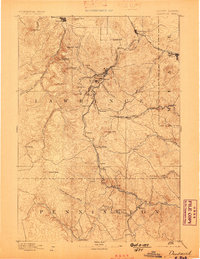
Deadwood and Lead anchor this late-19th-century survey of the Black Hills, showing the region at the peak of its early mining and rail expansion. The landscape is defined by a dense network of gulches and peaks, including Terry Peak and Bald Mtn, which supported a cluster of satellite settlements such as Terraville, Pluma, and Gayville. This map captures the industrial character of the era through the concentration of named gulches like Blacktail Gulch and Two Bit Gulch, which were central to local gold prospecting operations.
Find a feature on this map
67 named features on this map. Tap any name to fly to it.
Don’t see what you’re looking for? This feature index may not catch every label — zoom into the map to look around manually.
Map Details
Editions of this 1894 Deadwood Map
2 editions found
Other maps of this area

1893 · Rapid
USGS Topo · 1:125,000

1894 · Deadwood
USGS Topo · 1:125,000

1894 · Hermosa
USGS Topo · 1:125,000

1896 · Harney Peak
USGS Topo · 1:125,000

1898 · Sundance
USGS Topo · 1:125,000

1898 · Rapid
USGS Topo · 1:125,000

1899 · Sturgis
USGS Topo · 1:62,500

1899 · Newcastle
USGS Topo · 1:125,000

1900 · Spearfish
USGS Topo · 1:62,500

1901 · Hermosa
USGS Topo · 1:125,000