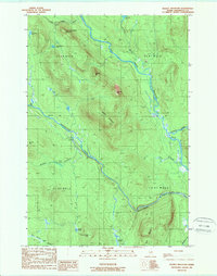
1989 Map of Deasey Mountain
USGS Topo · Published 1989About this map
The East Branch Penobscot River carves a dominant path through this heavily forested portion of Penobscot County, where it meets the Wassataquoik Stream and the Seboeis River. This 1989 provisional survey documents a landscape defined by significant peaks, including Deasey Mountain, Lunksoos Mtn, and Barnard Mtn. The terrain is marked by a network of waterways and ponds such as Lunksoos Lake and Big Robar Pond, highlighting the complex drainage patterns of the Maine woods. A notable human-made feature is the Monument Line, which cuts a straight east-west path across the topography, intersecting with the meandering Wassataquoik Stream near Orin Falls. The lack of developed roads or settlements on this sheet reflects the area's use for timber and recreation in the late twentieth century, preserved here in its raw topographical form.
Find a feature on this map
27 named features on this map. Tap any name to fly to it.
Don’t see what you’re looking for? This feature index may not catch every label — zoom into the map to look around manually.
Map Details
Editions of this 1989 Deasey Mountain Map
2 editions found
Other maps of this area

1927 · Katahdin
USGS Topo · 1:48,000

1930 · Katahdin
USGS Topo · 1:62,500

1949 · Katahdin
USGS Topo · 1:62,500

1953 · Stacyville
USGS Topo · 1:62,500

1954 · Shin Pond
USGS Topo · 1:62,500

1954 · Presque Isle
USGS Topo · 1:250,000

1954 · Millinocket
USGS Topo · 1:250,000

1955 · Traveler Mountain
USGS Topo · 1:62,500

1958 · Presque Isle
USGS Topo · 1:250,000

1958 · Millinocket
USGS Topo · 1:250,000