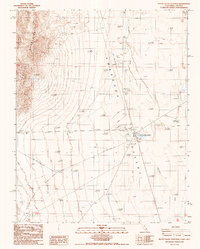
1987 Map of Death Valley Junction
USGS Topo · Published 1987About this map
Death Valley Junction serves as the focal point of this arid borderlands survey, situated where the Amargosa Desert meets the eastern foothills of the Funeral Mountains. The settlement landscape is defined by its industrial and transportation history, evidenced by the Old RR Grade and infrastructure such as a Sub Sta, Landing Strip, and several Tanks. In the flatter reaches of the desert to the east, the Amargosa River creates a drainage pattern leading toward areas of Mud & Alkali. Outside the main junction, the map records the Hog Ranch (Site) and a small Cem, alongside numerous Prospects and Borrow Pit excavations that reflect the region's long-standing mining and material-extraction activities. The state line between Inyo County, California and Nye County, Nevada bisects the northeastern corner of the map near Pyramid peak.
Find a feature on this map
18 named features on this map. Tap any name to fly to it.
Don’t see what you’re looking for? This feature index may not catch every label — zoom into the map to look around manually.
Map Details
Editions of this 1987 Death Valley Junction Map
This is the sole edition of this map. No revisions or reprints were ever made.
Other maps of this area

1908 · Furnace Creek
USGS Topo · 1:250,000

1910 · Furnace Creek
USGS Topo · 1:250,000

1940 · Eagle Tank
USGS Topo · 1:62,500

1948 · Death Valley
USGS Topo · 1:250,000

1951 · Funeral Peak
USGS Topo · 1:62,500

1951 · Eagle Mtn
USGS Topo · 1:62,500

1952 · Ash Meadows
USGS Topo · 1:62,500

1952 · Ryan
USGS Topo · 1:62,500

1954 · Death Valley
USGS Topo · 1:250,000

1956 · Death Valley
USGS Topo · 1:250,000