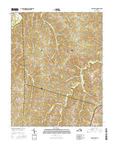
2016 Map of Deatonville
USGS Topo · Published 2016About this map
Deatonville and the surrounding Amelia County countryside are defined by a network of rural routes and historic family burial grounds. The landscape is bisected by the Appomattox River and defined by numerous tributaries such as Saylers Cr and Sandy Cr. The settlement patterns here reflect a long agricultural history, with small communities like Rodophil and Gills serving as local hubs. Genealogists will find significant value in the numerous recorded cemeteries, including Sandy Creek Cem, Bethel Cem, and Star Hope Cem. The road network, featuring names like Morrissetts Mill Rd and Gully Tavern Rd, suggests the location of former local industries and gathering places that shaped this portion of Central Virginia. This 2016 survey documents the enduring rural character of the region where Amelia, Prince Edward, and Nottoway counties meet.
Find a feature on this map
67 named features on this map. Tap any name to fly to it.
Don’t see what you’re looking for? This feature index may not catch every label — zoom into the map to look around manually.
Map Details
Editions of this 2016 Deatonville Map
This is the sole edition of this map. No revisions or reprints were ever made.
Other maps of this area

1891 · Farmville
USGS Topo · 1:125,000

1893 · Farmville
USGS Topo · 1:125,000

1947 · Roanoke
USGS Topo · 1:250,000

1958 · Farmville
USGS Topo · 1:62,500

1958 · Jetersville
USGS Topo · 1:62,500

1958 · Crewe
USGS Topo · 1:62,500

1958 · Keysville
USGS Topo · 1:62,500

1959 · Roanoke
USGS Topo · 1:250,000

1963 · Roanoke
USGS Topo · 1:250,000
1968 · Ballsville
USGS Topo · 1:24,000