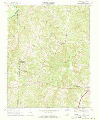
1968 Map of Deatonville
USGS Topo · Published 1971About this map
Saylers Creek Battlefield State Park dominates the western portion of this landscape, marking a site of significant American conflict where the Hillsman House stands as a tangible link to the past. The terrain is defined by a dense network of waterways including Sandy Creek, Saylers Creek, and the Appomattox River, which forms the boundary between Prince Edward and Amelia counties. This 1968 field-checked survey reveals a rural society structured around crossroads and community landmarks such as Deatonville and Rodophil.
Find a feature on this map
33 named features on this map. Tap any name to fly to it.
Don’t see what you’re looking for? This feature index may not catch every label — zoom into the map to look around manually.
Map Details
Editions of this 1968 Deatonville Map
2 editions found
Other maps of this area

1891 · Farmville
USGS Topo · 1:125,000

1893 · Farmville
USGS Topo · 1:125,000

1947 · Roanoke
USGS Topo · 1:250,000

1958 · Farmville
USGS Topo · 1:62,500

1958 · Jetersville
USGS Topo · 1:62,500

1958 · Crewe
USGS Topo · 1:62,500

1958 · Keysville
USGS Topo · 1:62,500

1959 · Roanoke
USGS Topo · 1:250,000

1963 · Roanoke
USGS Topo · 1:250,000
1968 · Ballsville
USGS Topo · 1:24,000