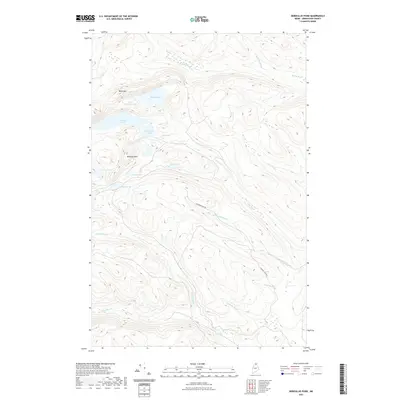
2021 Map of Deboullie Pond
USGS Topo · Published 2021About this map
Deboullie Pond and its neighboring waters define this interior stretch of North Maine Woods, where a dense network of glacial ponds is framed by significant peaks. The map traces the rugged verticality of Black Mtn and Whitman Mtn, which rise sharply above the water-filled basins of Little Black Ponds and Pushineer Pond. The hydrologic pattern here is complex, with the Red River and Rocky Brook draining the highlands, supplemented by small, isolated basins like Stink Pond and Fish Pond. Human presence is minimal and temporary, primarily represented by the Chapman Tote Rd, a classic Maine logging route that winds through the valley of Threemile Brook. This survey illustrates a landscape managed for timber and recreation, where the names of small waters like Perch Pond and Denny Pond hint at the area's long-standing value for wilderness angling and remote backwoods travel.
Find a feature on this map
21 named features on this map. Tap any name to fly to it.
Don’t see what you’re looking for? This feature index may not catch every label — zoom into the map to look around manually.
Map Details
Editions of this 2021 Deboullie Pond Map
This is the sole edition of this map. No revisions or reprints were ever made.
Other maps of this area

1928 · Eagle Lake
USGS Topo · 1:48,000

1928 · Winterville
USGS Topo · 1:48,000

1930 · St Francis
USGS Topo · 1:48,000

1931 · Fish River Lake
USGS Topo · 1:48,000

1931 · Eagle Lake
USGS Topo · 1:62,500

1931 · Winterville
USGS Topo · 1:62,500

1933 · St Francis
USGS Topo · 1:62,500

1935 · Fish River Lake
USGS Topo · 1:62,500

1954 · Presque Isle
USGS Topo · 1:250,000

1958 · Presque Isle
USGS Topo · 1:250,000