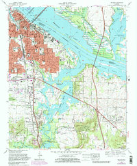
1975 Map of Decatur
USGS Topo · Published 1983About this map
Wheeler Lake and the Tennessee River dominate the northern landscape of this 1970s revision, acting as a natural boundary between Limestone and Morgan Counties. The city of Decatur is shown in a period of significant suburban expansion, with purple-tinted urban updates reaching toward Fairview, Austinville, and Oakworth. The local transportation network is anchored by the Louisville and Nashville railroad and the Keller Memorial Bridge, which provides a vital link across the water toward Mooresville.
Find a feature on this map
80 named features on this map. Tap any name to fly to it.
Don’t see what you’re looking for? This feature index may not catch every label — zoom into the map to look around manually.
Map Details
Editions of this 1975 Decatur Map
3 editions found
Other maps of this area

1888 · Cullman
USGS Topo · 1:125,000

1888 · Huntsville
USGS Topo · 1:125,000

1892 · Cullman
USGS Topo · 1:125,000

1892 · Huntsville
USGS Topo · 1:125,000

1935 · Danville
USGS Topo · 1:48,000

1936 · Hartselle
USGS Topo · 1:24,000

1936 · Decatur
USGS Topo · 1:24,000

1936 · Stewart Cross Roads
USGS Topo · 1:24,000

1936 · Trinity
USGS Topo · 1:24,000

1936 · Somerville
USGS Topo · 1:24,000