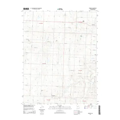
2015 Map of Dederick
USGS Topo · Published 2015About this map
The unincorporated community of Dederick sits in the northeast corner of this Vernon County landscape, situated along the ridge lines where Robinson Br and W Fork Clear Cr originate. The terrain is defined by a dense network of country roads following the section lines of the Public Land Survey System, revealing a pattern of rural residency and agriculture. To the south, the settlement of Sandstone is anchored by the Sandstone Cemetery, one of several burial grounds that serve as vital touchstones for local genealogy, including Butler Cemetery, Stepp Cemetery, and Robinson Cemetery. Water resources are scattered throughout the quadrangle, ranging from the meandering Clear Creek and Wilson Br to named impoundments such as C H Jones Lake and Marvin Vickers Lake. Distinctive geographical markers like Oak Ridge and Rocky Hollow provide a sense of the local topography within the Osage Plains region.
Find a feature on this map
66 named features on this map. Tap any name to fly to it.
Don’t see what you’re looking for? This feature index may not catch every label — zoom into the map to look around manually.
Map Details
Editions of this 2015 Dederick Map
This is the sole edition of this map. No revisions or reprints were ever made.
Other maps of this area

1886 · Nevada
USGS Topo · 1:125,000

1894 · Nevada
USGS Topo · 1:125,000

1933 · Camp Clark
USGS Topo · 1:24,000

1938 · Horton
USGS Topo · 1:24,000

1939 · Horton
USGS Topo · 1:24,000

1939 · Dederick
USGS Topo · 1:24,000

1939 · Eldorado Springs North
USGS Topo · 1:24,000
1939 · Harwood
USGS Topo · 1:24,000

1939 · Eldorado Springs South
USGS Topo · 1:24,000
1940 · Harwood
USGS Topo · 1:24,000