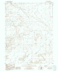
1991 Map of Dee Pass
USGS Topo · Published 1991About this map
Dee Pass and Duma Point command the high ground of this Grand County desert landscape, where seasonal drainage patterns define the local geography. The area is marked by a network of ephemeral watercourses including Salt Wash, Thompson Wash, and the deep cut of Tenmile Canyon. These washes have long served as natural corridors through the arid terrain, directing the placement of primitive 4WD tracks and utility corridors like the Trans Lines in the east.
Find a feature on this map
17 named features on this map. Tap any name to fly to it.
Don’t see what you’re looking for? This feature index may not catch every label — zoom into the map to look around manually.
Map Details
Editions of this 1991 Dee Pass Map
This is the sole edition of this map. No revisions or reprints were ever made.
Other maps of this area

1885 · San Rafael
USGS Topo · 1:250,000

1885 · La Sal
USGS Topo · 1:250,000

1951 · The Knoll
USGS Topo · 1:62,500

1952 · Moab 3 NE
USGS Topo · 1:24,000

1952 · Tidwell 4 NE
USGS Topo · 1:24,000

1952 · Moab 3 NW
USGS Topo · 1:24,000

1954 · Tidwell 1 NE
USGS Topo · 1:24,000

1954 · Tidwell 1 SE
USGS Topo · 1:24,000

1954 · Green River
USGS Topo · 1:62,500

1956 · Salina
USGS Topo · 1:250,000