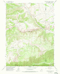
1962 Map of Deep Creek Canyon
USGS Topo · Published 1972About this map
Currant Creek flows through the center of this 1962 landscape, winding past the Fishponds as it moves toward the southern border of the quadrangle. This area of the Uintah Basin is defined by a dense network of drainages and high-altitude terrain, including the steep descent of Deep Creek Canyon and the secluded Wildcat Canyon. The map captures the remote character of the Wasatch and Duchesne county line before modern development, showing only a sparse network of jeep trails and a single telephone line crossing the northern slopes. Toward the south, the Strawberry River and Bear River anchor the drainage system, while numerous springs and seasonal watercourses like Water Hollow and North Fork Creek illustrate the complex hydrology of this high-plateau environment.
Find a feature on this map
16 named features on this map. Tap any name to fly to it.
Don’t see what you’re looking for? This feature index may not catch every label — zoom into the map to look around manually.
Map Details
Editions of this 1962 Deep Creek Canyon Map
3 editions found
Other maps of this area

1885 · Salt Lake
USGS Topo · 1:250,000

1885 · Uinta
USGS Topo · 1:250,000

1907 · Strawberry Valley
USGS Topo · 1:125,000

1909 · Strawberry Valley
USGS Topo · 1:125,000

1954 · Salt Lake City
USGS Topo · 1:250,000

1958 · Salt Lake City
USGS Topo · 1:250,000

1960 · Salt Lake City
USGS Topo · 1:250,000

1962 · Deep Creek Canyon
USGS Topo · 1:24,000

1962 · Fruitland
USGS Topo · 1:24,000

1962 · Raspberry Knoll
USGS Topo · 1:24,000