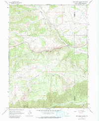
1962 Map of Deep Creek Canyon
USGS Topo · Published 1980About this map
The Strawberry River flows through the southern reaches of this landscape, marking a remote mountain corridor within the High Uintas region. Surveyed in the early 1960s, the terrain is defined by the sharp convergence of the Deep Creek Canyon and Currant Creek drainages. A notable concentration of Fishponds along the creek indicates the area's development for local resource management and recreation during this era.
Find a feature on this map
16 named features on this map. Tap any name to fly to it.
Don’t see what you’re looking for? This feature index may not catch every label — zoom into the map to look around manually.
Map Details
Editions of this 1962 Deep Creek Canyon Map
3 editions found
Other maps of this area

1885 · Salt Lake
USGS Topo · 1:250,000

1885 · Uinta
USGS Topo · 1:250,000

1907 · Strawberry Valley
USGS Topo · 1:125,000

1909 · Strawberry Valley
USGS Topo · 1:125,000

1954 · Salt Lake City
USGS Topo · 1:250,000

1958 · Salt Lake City
USGS Topo · 1:250,000

1960 · Salt Lake City
USGS Topo · 1:250,000

1962 · Deep Creek Canyon
USGS Topo · 1:24,000

1962 · Fruitland
USGS Topo · 1:24,000

1962 · Raspberry Knoll
USGS Topo · 1:24,000