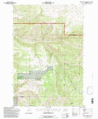
1995 Map of Deep Creek Park
USGS Topo · Published 1997About this map
Lewis and Clark National Forest encompasses the entirety of this mountainous landscape along the border of Cascade and Meagher counties. The terrain is defined by a complex network of drainages including Deep Creek, Temple Gulch, and Loblolly Gulch, which feed into the larger river systems of the region. While primarily a wilderness area, the map records the legacy of land use through labeled prospects and localized clearings such as Simmons Park. High elevations are anchored by Kings Hill Butte and Desolation Peak, while the central portion features the namesake Deep Creek Park. The presence of the Figure 8 Loop trail and numerous named springs like Robertson Spring indicates a landscape managed for both timber and recreation in the mid-1990s. The map also meticulously labels cadastral survey plots, identified as PB 37 through PB 41, which detail the specific land divisions within the forest boundaries.
Find a feature on this map
31 named features on this map. Tap any name to fly to it.
Don’t see what you’re looking for? This feature index may not catch every label — zoom into the map to look around manually.
Map Details
Editions of this 1995 Deep Creek Park Map
This is the sole edition of this map. No revisions or reprints were ever made.
Other maps of this area

1886 · Great Falls
USGS Topo · 1:250,000

1886 · Fort Logan
USGS Topo · 1:250,000

1948 · White Sulphur Springs
USGS Topo · 1:250,000

1954 · Great Falls
USGS Topo · 1:250,000

1957 · Great Falls
USGS Topo · 1:250,000

1958 · White Sulphur Springs
USGS Topo · 1:250,000

1961 · White Sulphur Springs
USGS Topo · 1:250,000

1965 · White Sulphur Springs
USGS Topo · 1:250,000

1966 · Lingshire NE
USGS Topo · 1:24,000
1971 · Bald Hills
USGS Topo · 1:24,000