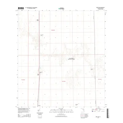
2015 Map of Deep Lake
USGS Topo · Published 2015About this map
Big Cypress National Preserve dominates this portion of the Florida Everglades, revealing a landscape defined by expansive prairies and isolated hammock heads. The settlement of Jerome sits at the southern edge of the sheet, serving as a rare point of habitation in this wet wilderness. Running north-south, Sr 29 provides the primary transit corridor, passing the namesake Deep Lake and the distinct wooded feature of Hollywood Head. The map illustrates the varied terrain of the region, from the open expanse of Rock Island Prairie and Airplane Prairie to the namesake Rock Island elevation. These features represent the natural hydrology and ecological boundaries of Collier County as they were documented in the mid-2010s, showing the intersection of preserved lands and the rural roads that navigate them like Turner River Rd.
Find a feature on this map
14 named features on this map. Tap any name to fly to it.
Don’t see what you’re looking for? This feature index may not catch every label — zoom into the map to look around manually.
Map Details
Editions of this 2015 Deep Lake Map
This is the sole edition of this map. No revisions or reprints were ever made.
Other maps of this area

1956 · Miami
USGS Topo · 1:250,000

1956 · West Palm Beach
USGS Topo · 1:250,000

1957 · West Palm Beach
USGS Topo · 1:250,000

1958 · West Palm Beach
USGS Topo · 1:250,000

1958 · Miami
USGS Topo · 1:250,000

1958 · Catherine Island
USGS Topo · 1:24,000

1959 · Miles City
USGS Topo · 1:24,000

1959 · Deep Lake
USGS Topo · 1:24,000

1959 · Deep Lake SW
USGS Topo · 1:24,000
1962 · Catherine Island
USGS Topo · 1:24,000