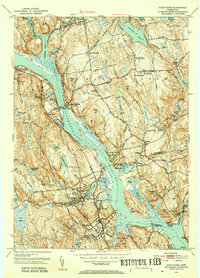
1952 Map of Deep River
USGS Topo · Published 1953About this map
The Connecticut River bisects this 1952 landscape, anchoring a network of historic riverfront settlements including Deep River, Chester, and Hadlyme. The map reveals the intricate water-driven industrial and social geography of the era, from the Johnson Mill on the Moodus River to the ferry crossing at Gillette Castle State Park. Local heritage is densely recorded in a series of family and community landmarks such as the Old Cove Burying Ground and Mt Parnassus Burying Ground, alongside educational and civic centers like Nathan Hale High Sch and the East Haddam Lookout Tower. The New York New Haven and Hartford RR follows the western shoreline, illustrating the transition from river-based transport to the rail-and-road connections of the mid-20th century. High elevations like Mt Parnassus and Wigwam Hill contrast with the complex tidal inlets and islands like Selden Neck.
Find a feature on this map
93 named features on this map. Tap any name to fly to it.
Don’t see what you’re looking for? This feature index may not catch every label — zoom into the map to look around manually.
Map Details
Editions of this 1952 Deep River Map
3 editions found
Other maps of this area

1892 · Gilead
USGS Topo · 1:62,500

1893 · Guilford
USGS Topo · 1:62,500

1893 · Middletown
USGS Topo · 1:62,500

1893 · Saybrook
USGS Topo · 1:62,500

1906 · Farmington
USGS Topo · 1:125,000

1941 · Lyme
USGS Topo · 1:31,680

1944 · Essex
USGS Topo · 1:31,680

1944 · Deep River
USGS Topo · 1:31,680

1945 · Middle Haddam
USGS Topo · 1:31,680
1945 · Colchester
USGS Topo · 1:31,680