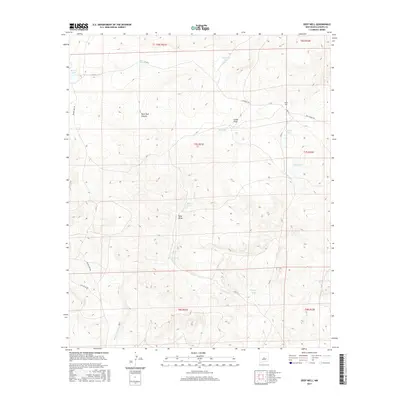
2017 Map of Deep Well
USGS Topo · Published 2017About this map
Deep Well and a series of water management features define this high-desert landscape in Chaves County, New Mexico. The geography is characterized by an extensive network of livestock water sources, including family-named or agency-labeled points such as Joes Tank, Bill Parks Tank, and BLM Lake. The map reveals a ranching economy supported by seasonal drainage features like China Draw and Rock Tank Canyon, which cut through the undulating terrain. Small, vital bodies of water such as Catfish Tank and South Lake are connected by a sparse grid of local thoroughfares, including Deepwell Rd and Rock House Rd. This 2017 survey by the U.S. Geological Survey provides a clear view of the water-reliant infrastructure necessary for survival and industry in this arid environment, showing the continued importance of land divisions and access routes like Brown Lake Rd and Whiteflat Rd.
Find a feature on this map
27 named features on this map. Tap any name to fly to it.
Don’t see what you’re looking for? This feature index may not catch every label — zoom into the map to look around manually.
Map Details
Editions of this 2017 Deep Well Map
This is the sole edition of this map. No revisions or reprints were ever made.
Other maps of this area

1955 · Roswell
USGS Topo · 1:250,000

1958 · Roswell
USGS Topo · 1:250,000

1962 · Roswell
USGS Topo · 1:250,000

1962 · Rock House Canyon
USGS Topo · 1:24,000
1963 · Barn Draw
USGS Topo · 1:24,000

1967 · Round Mountain SE
USGS Topo · 1:24,000

1967 · North Lake
USGS Topo · 1:24,000

1967 · White Flat
USGS Topo · 1:24,000
1967 · White Flat SE
USGS Topo · 1:24,000
1967 · Elsie Canyon
USGS Topo · 1:24,000