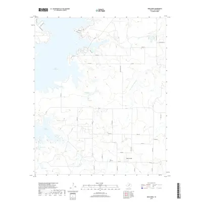
2019 Map of Deer Creek
USGS Topo · Published 2019About this map
Deer Creek serves as the focal point of this Clay County landscape, where the namesake watercourse, Deer Cr, flows through a region defined by ranching roads and significant water management. The settlement area includes the Deer Creek Cem, a key site for local genealogical research. To the west, the massive expanse of Lake Arrowhead dominates the terrain, its irregular shoreline creating a complex series of inlets and points accessed by rural routes like Halsell Rd and Dale Ranch Rd.
Find a feature on this map
39 named features on this map. Tap any name to fly to it.
Don’t see what you’re looking for? This feature index may not catch every label — zoom into the map to look around manually.
Map Details
Editions of this 2019 Deer Creek Map
This is the sole edition of this map. No revisions or reprints were ever made.
Other maps of this area

1954 · Wichita Falls
USGS Topo · 1:250,000

1956 · Sloop Creek
USGS Topo · 1:24,000

1956 · Henrietta
USGS Topo · 1:62,500

1957 · Wichita Falls East
USGS Topo · 1:62,500

1958 · Wichita Falls
USGS Topo · 1:250,000

1962 · Windthorst
USGS Topo · 1:24,000

1963 · Deer Creek
USGS Topo · 1:24,000

1963 · Scotland
USGS Topo · 1:24,000

1964 · Scotland SE
USGS Topo · 1:24,000
1964 · Joy
USGS Topo · 1:24,000