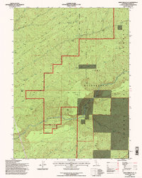
1995 Map of Deer Creek Flat
USGS Topo · Published 1998About this map
The Ishi Wilderness dominates this rugged portion of Lassen National Forest, characterized by deep canyons and seasonal watercourses. The landscape is defined by the drainages of Mill Creek and Deer Creek, which cut through the volcanic plateaus of northern California. Human presence is marked by a network of historic campsites and springs, including Leininger Camp and the Roberts Place. This 1995 revision provides a detailed view of the transitional terrain between the Sacramento Valley and the higher Cascades, showing the intersection of conservation areas like State Game Refuge 1-G and historic movement corridors like the Lassen Trail. The map captures the specialized backcountry infrastructure of the era, from the Apperson Cow Camp Spring to isolated landmarks such as Maak Cove and Digger Pine Flat.
Find a feature on this map
45 named features on this map. Tap any name to fly to it.
Don’t see what you’re looking for? This feature index may not catch every label — zoom into the map to look around manually.
Map Details
Editions of this 1995 Deer Creek Flat Map
This is the sole edition of this map. No revisions or reprints were ever made.
Other maps of this area

1886 · Lassen Peak
USGS Topo · 1:250,000

1891 · Chico
USGS Topo · 1:125,000

1892 · Lassen Peak
USGS Topo · 1:250,000

1893 · Chico
USGS Topo · 1:125,000

1894 · Lassen Peak
USGS Topo · 1:250,000

1895 · Chico
USGS Topo · 1:125,000

1912 · Singer Creek
USGS Topo · 1:31,680

1935 · Paynes Creek
USGS Topo · 1:96,000

1941 · Mineral
USGS Topo · 1:125,000

1944 · Richardson Springs
USGS Topo · 1:62,500