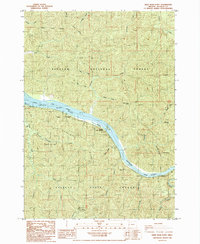
1985 Map of Deer Head Point
USGS Topo · Published 1985About this map
The Umpqua River carves a deep winding path through the heavy timberlands of coastal Oregon, serving as the central artery for this 1980s landscape. Along its banks, the Umpqua State Wayside hosts the Lewis and Clark Monument, marking the historical reach of early exploration near the large bend at Brandy Bar. The terrain is defined by the meeting of two major timber reserves, with the Siuslaw National Forest to the north and the Elliott State Forest to the south. This era is characterized by active resource management and early river-based recreation, evidenced by numerous small drainages like Johnson Creek and Franklin Creek that feed into the main channel. Topographic landmarks such as Echo Island and the prominent Charlotte Ridge provide vertical relief in an area primarily dedicated to forestry and preservation.
Find a feature on this map
34 named features on this map. Tap any name to fly to it.
Don’t see what you’re looking for? This feature index may not catch every label — zoom into the map to look around manually.
Map Details
Editions of this 1985 Deer Head Point Map
This is the sole edition of this map. No revisions or reprints were ever made.
Other maps of this area

1919 · Earl
USGS Topo · 1:48,000

1920 · Siltcoos Lake
USGS Topo · 1:62,500

1923 · Reedsport
USGS Topo · 1:62,500

1941 · Siltcoos Lake
USGS Topo · 1:62,500

1942 · Siltcoos Lake
USGS Topo · 1:62,500

1942 · Reedsport
USGS Topo · 1:62,500

1943 · Goodwin Peak
USGS Topo · 1:62,500

1954 · Coos Bay
USGS Topo · 1:250,000

1955 · Scottsburg
USGS Topo · 1:62,500
1956 · Reedsport
USGS Topo · 1:62,500