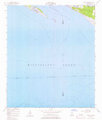
1954 Map of Deer Island
USGS Topo · Published 1967About this map
Deer Island stretches across the northern portion of this coastal survey, serving as a natural barrier between the open waters of the Mississippi Sound and the protected reaches of Biloxi Bay. The map provides a detailed look at the aquatic geography of the Mississippi coastline in the mid-1950s, documenting the vital Intracostal Waterway as it traverses the sound with a noted project depth of 12 feet. Along the shoreline, intricate marshy inlets like Ramsay Bayou and Simmons Bayou intersect the land, while Grand Bayou cuts through the island itself. The survey also captures the indefinite boundary between Harrison and Jackson counties as it extends into the coastal waters, reflecting the era's marine surveying standards and the shifting nature of this tidal landscape.
Find a feature on this map
10 named features on this map. Tap any name to fly to it.
Don’t see what you’re looking for? This feature index may not catch every label — zoom into the map to look around manually.
Map Details
Editions of this 1954 Deer Island Map
3 editions found
Other maps of this area

1941 · Horn Island
USGS Topo · 1:62,500

1942 · Horn Island
USGS Topo · 1:62,500

1943 · Pascagoula
USGS Topo · 1:62,500

1950 · Dog Keys Pass
USGS Topo · 1:24,000

1950 · Ship Island
USGS Topo · 1:24,000

1953 · Mobile
USGS Topo · 1:250,000

1954 · Ocean Springs
USGS Topo · 1:24,000

1954 · Biloxi
USGS Topo · 1:24,000

1954 · Deer Island
USGS Topo · 1:24,000

1954 · Biloxi
USGS Topo · 1:62,500