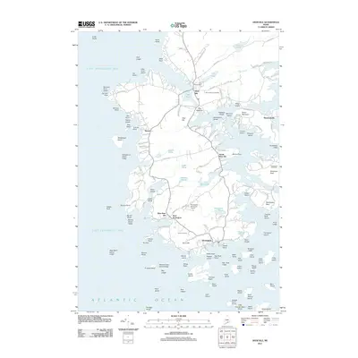
2011 Map of Deer Isle
USGS Topo · Published 2011About this map
Stonington and the village of Deer Isle anchor this coastal landscape, illustrating the enduring relationship between the community and the Atlantic Ocean. The map shows a highly indented coastline characterized by numerous points and ledges, such as Dunham Point and Salmon Point, and an array of named islands including Sheephead Island and Andrew Island. Settlement patterns are concentrated along local arteries like Sunshine Rd and Oceanville Rd, connecting small communities such as Sunset, Mountainville, and West Stonington. Local infrastructure is evident through the Stonington Municipal Airport and the Lily Pond Dam. For genealogists, several local burial grounds are documented, including Mount Adams Cemetery and Forest Cemetery. The geographic complexity of the Deer Island Thorofare reveals a navigable but challenging maritime environment, while inland bodies like Holt Pond and Georges Pond provide a contrast to the surrounding salt water.
Find a feature on this map
162 named features on this map. Tap any name to fly to it.
Don’t see what you’re looking for? This feature index may not catch every label — zoom into the map to look around manually.
Map Details
Editions of this 2011 Deer Isle Map
This is the sole edition of this map. No revisions or reprints were ever made.
Other maps of this area

1902 · Castine
USGS Topo · 1:62,500

1904 · Deer Isle
USGS Topo · 1:62,500

1904 · Castine
USGS Topo · 1:62,500

1904 · Bluehill
USGS Topo · 1:62,500

1904 · Vinalhaven
USGS Topo · 1:62,500

1905 · Penobscot Bay
USGS Topo · 1:125,000

1941 · Castine
USGS Topo · 1:62,500

1941 · Vinalhaven
USGS Topo · 1:62,500

1942 · Deer Isle
USGS Topo · 1:62,500
1943 · Castine
USGS Topo · 1:62,500