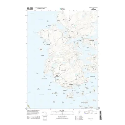
2014 Map of Deer Isle
USGS Topo · Published 2014About this map
Stonington and the surrounding islands of East Penobscot Bay define this 2014 survey of Hancock County. The map details a landscape deeply connected to the sea, from the industrial activity near Stonington Municipal Airport to the cluster of historical settlements like The Haulover, Mountainville, and West Deer Isle. Genealogists will find several burial grounds mapped with precision, including Old Settlers Cem, Mt Adams Cem, and Hillside Cem, which preserve the names of early island families. The intricate coastline is dotted with landmarks such as Trundys Point, Dunham Point, and Fifield Point, while the interior is punctuated by numerous freshwater bodies like Lily Pond and Toffet Pond. This era shows the developed road network connecting these coastal hamlets, including routes like Sunshine Rd and Oceanville Rd, reflecting a community centered on its coves and harbors.
Find a feature on this map
178 named features on this map. Tap any name to fly to it.
Don’t see what you’re looking for? This feature index may not catch every label — zoom into the map to look around manually.
Map Details
Editions of this 2014 Deer Isle Map
This is the sole edition of this map. No revisions or reprints were ever made.
Other maps of this area

1902 · Castine
USGS Topo · 1:62,500

1904 · Deer Isle
USGS Topo · 1:62,500

1904 · Castine
USGS Topo · 1:62,500

1904 · Bluehill
USGS Topo · 1:62,500

1904 · Vinalhaven
USGS Topo · 1:62,500

1905 · Penobscot Bay
USGS Topo · 1:125,000

1941 · Castine
USGS Topo · 1:62,500

1941 · Vinalhaven
USGS Topo · 1:62,500

1942 · Deer Isle
USGS Topo · 1:62,500
1943 · Castine
USGS Topo · 1:62,500