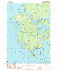
1983 Map of Deer Isle
USGS Topo · Published 1983About this map
The coastal village of Stonington anchors the southern tip of this island landscape, where the granite industry and maritime commerce meet the waters of the Thoroughfare. This 1983 survey illustrates a complex geography of coves and narrows, including Crockett Cove and Southeast Harbor, which have long defined the region's seafaring character. Local genealogy and land use are well-documented through features like Mt Adams Cem, Forest Cem, and Greenwood Cem, alongside several quarries that highlight the island's geological heritage.
Find a feature on this map
123 named features on this map. Tap any name to fly to it.
Don’t see what you’re looking for? This feature index may not catch every label — zoom into the map to look around manually.
Map Details
Editions of this 1983 Deer Isle Map
This is the sole edition of this map. No revisions or reprints were ever made.
Other maps of this area

1902 · Castine
USGS Topo · 1:62,500

1904 · Deer Isle
USGS Topo · 1:62,500

1904 · Castine
USGS Topo · 1:62,500

1904 · Bluehill
USGS Topo · 1:62,500

1904 · Vinalhaven
USGS Topo · 1:62,500

1905 · Penobscot Bay
USGS Topo · 1:125,000

1941 · Castine
USGS Topo · 1:62,500

1941 · Vinalhaven
USGS Topo · 1:62,500

1942 · Deer Isle
USGS Topo · 1:62,500
1943 · Castine
USGS Topo · 1:62,500