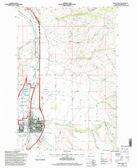
1996 Map of Deer Lodge
USGS Topo · Published 1998About this map
Grant Kohrs Ranch National Historic Site preserves a significant legacy of the open-range cattle era, situated along the banks of the Clark Fork north of the main settlement. The town of Deer Lodge serves as a civic hub, centered on its Courthouse, Post Office, and a notable Prison Museum. This mid-1990s landscape is defined by the convergence of several waterways, including Fred Burr Creek and Peterson Creek, which meet the river in a valley characterized by irrigation ditches like the O'Neil Ditch and the grazing lands of the ranching frontier.
Find a feature on this map
31 named features on this map. Tap any name to fly to it.
Don’t see what you’re looking for? This feature index may not catch every label — zoom into the map to look around manually.
Map Details
Editions of this 1996 Deer Lodge Map
This is the sole edition of this map. No revisions or reprints were ever made.
Other maps of this area

1889 · Helena
USGS Topo · 1:250,000

1893 · Helena
USGS Topo · 1:250,000

1899 · Helena
USGS Topo · 1:250,000

1903 · Helena
USGS Topo · 1:250,000

1947 · Butte
USGS Topo · 1:250,000

1958 · Butte
USGS Topo · 1:250,000

1958 · Avon
USGS Topo · 1:62,500

1958 · Garrison
USGS Topo · 1:62,500

1959 · Deer Lodge
USGS Topo · 1:62,500

1960 · Butte
USGS Topo · 1:250,000