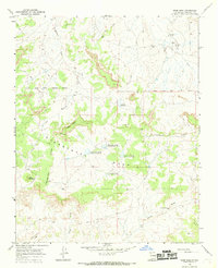
1966 Map of Deer Mesa
USGS Topo · Published 1969About this map
The Jicarilla Apache Indian Reservation Boundary stretches across the northern portion of this high-desert landscape, where the Continental Divide winds its way through sandstone formations. This mid-1960s survey captures a remote region defined by expansive geological features like Snathyel Mesa and Deer Mesa. The arid environment required significant water management, evidenced by a series of infrastructure projects including Encino Dam No. 85 and Encino Dam No. 83. These water structures, along with the Armijo Reservoir and scattered landmarks like the Alexander Windmill, illustrate the vital role of water sourcing for local use and livestock in Sandoval County's high country. A network of jeep trails provides the only access through the drainages of Peña Wash and Arroyo Torreon, marking a landscape that remained largely undeveloped during this era.
Find a feature on this map
22 named features on this map. Tap any name to fly to it.
Don’t see what you’re looking for? This feature index may not catch every label — zoom into the map to look around manually.
Map Details
Editions of this 1966 Deer Mesa Map
This is the sole edition of this map. No revisions or reprints were ever made.
Other maps of this area

1883 · Mt. Taylor
USGS Topo · 1:250,000

1886 · Mt. Taylor
USGS Topo · 1:250,000

1889 · Largo
USGS Topo · 1:250,000

1892 · Mt. Taylor
USGS Topo · 1:250,000

1895 · Largo
USGS Topo · 1:250,000

1899 · Mt. Taylor
USGS Topo · 1:250,000

1954 · Aztec
USGS Topo · 1:250,000

1958 · Aztec
USGS Topo · 1:250,000

1958 · Albuquerque
USGS Topo · 1:250,000
1961 · Ojo Encino Mesa
USGS Topo · 1:24,000