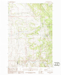
1986 Map of Deer Park
USGS Topo · Published 1986About this map
Sixteenmile Creek carves through the southern portion of this landscape, marking a significant corridor at the junction of Broadwater and Gallatin counties. The small settlement of Deer Park is situated along this watercourse, adjacent to the Old Railroad Grade which follows the winding canyon floor. This infrastructure reveals the historical importance of the canyon as a vital passage through the mountainous terrain during the mid-to-late 20th century.
Find a feature on this map
22 named features on this map. Tap any name to fly to it.
Don’t see what you’re looking for? This feature index may not catch every label — zoom into the map to look around manually.
Map Details
Editions of this 1986 Deer Park Map
This is the sole edition of this map. No revisions or reprints were ever made.
Other maps of this area

1886 · Fort Logan
USGS Topo · 1:250,000

1948 · White Sulphur Springs
USGS Topo · 1:250,000

1949 · Maudlow
USGS Topo · 1:62,500

1949 · Toston
USGS Topo · 1:62,500

1950 · Duck Creek Pass
USGS Topo · 1:62,500

1958 · White Sulphur Springs
USGS Topo · 1:250,000

1961 · White Sulphur Springs
USGS Topo · 1:250,000

1965 · White Sulphur Springs
USGS Topo · 1:250,000
1971 · Sulphur Bar Creek
USGS Topo · 1:24,000

1976 · Townsend
USGS Topo · 1:100,000